HUSSAR – Portable X-Band Synthetic Aperture Radar (SAR)
Discover the HUSSAR radar by SpaceForest, distinguished by its exceptional precision and advanced features. Designed for professional applications, it offers a range of impressive technical specifications that make it an indispensable tool in the field – scroll to read more!
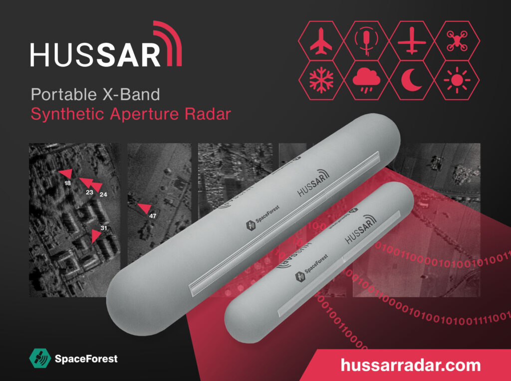
The advanced HUSSAR SAR radar provides a range of up to 15 km, a maximum altitude of 5 km, 15 cm resolution, and GMTI for precise ground moving target indication. Equipped with a gimbal-stabilized antenna, onboard real-time SAR processor, and FMCW radar with low probability of interception, it operates in Strip SAR and Spotlight modes for the highest resolution.
About HUSSAR Radar
HUSSAR Portable X-Band Radar: Advanced Surveillance and Motion Detection
The HUSSAR Portable X-band Radar, utilizing Synthetic Aperture Radar (SAR) technology, offers high-resolution terrain scanning and motion detection. When connected to an unmanned aircraft, plane or helicopter, it achieves a resolution of up to 15 cm (15 x 15 cm per pixel).
Key Features:
- High-Resolution Imaging: Delivers detailed scans with a resolution of up to 15 cm.
- All-Weather Operation: Functions effectively in all weather conditions.
- 24/7 Surveillance: Operates continuously, day and night.
- Portable and Versatile: Can be mounted on unmanned aircraft for flexible deployment.
- Enhanced Security Monitoring
- HUSSAR radar is a crucial tool for monitoring security-sensitive areas, particularly critical locations like national borders. It is widely used by border guards, police, and military personnel.
Benefits for Security:
- Uninterrupted Surveillance: Provides continuous monitoring regardless of weather and lighting conditions.
- Threat Detection: Capable of detecting and tracking unauthorized drones and vehicles.
- Rapid Response: Enhances the ability to respond quickly to potential threats.
- Diverse Applications of SAR Technology
- In addition to security, SAR technology has a broad range of applications in various fields.
Application Examples:
- Cartography: Assists in creating detailed maps for geographic studies.
- Surveying: Aids in precise land surveying and mapping.
- Urban Planning: Supports urban development and planning initiatives.
- Environmental Monitoring: Helps in monitoring and understanding environmental changes.
HUSSAR (SAR): Operation Diagram
Explore the operation diagram to understand how HUSSAR radar functions. Learn about its key features and technical specifications that set it apart from other SAR systems.

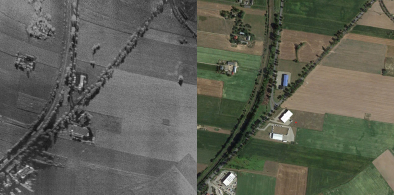
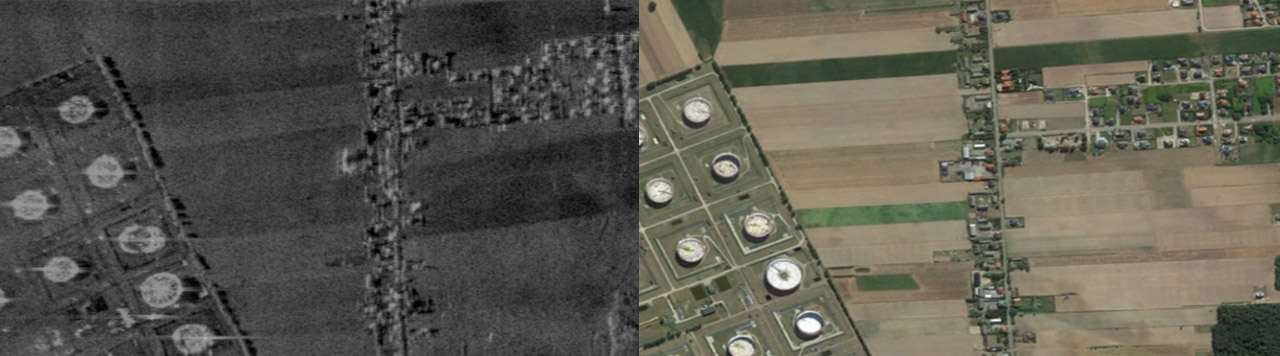
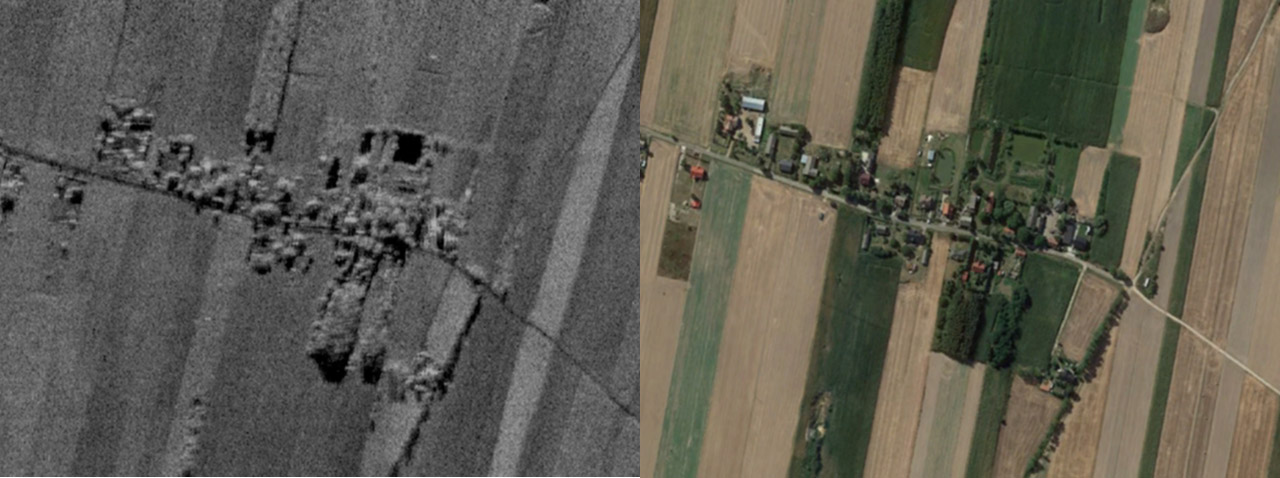
Examples of HUSSAR Radar Imaging vs Google Maps
Discover the power of HUSSAR radar technology through real-world examples comparing its imaging capabilities with Google Maps orthophotomaps. Each example showcases how HUSSAR enhances the visualization and analysis of various landscapes and infrastructures, providing detailed insights that traditional mapping methods may not capture. From railway tracks and industrial areas to rural fields and residential neighborhoods, explore how HUSSAR radar sets a new standard in accurate and comprehensive spatial imaging.
Example of HUSSAR Radar Imaging: Railway Tracks and Roads Compared to Google Maps Orthophotomap
Example of HUSSAR Radar Application: Imaging Industrial Infrastructure, Single-Family Houses, and Agricultural Fields Compared to Google Maps Orthophotomap
HUSSAR Radar Example: Imaging Buildings and Rural Fields vs Google Maps Orthophotomap
HUSSAR Radar: Technical Parameters
Advanced technical specifications of HUSSAR Portable X-Band Radar
The HUSSAR portable X-band radar is designed for high-resolution terrain scanning and motion detection, leveraging cutting-edge Synthetic Aperture Radar (SAR) technology. Below are the detailed technical parameters that make HUSSAR radar a superior choice for surveillance and various other applications.
HUSSAR Key Parameters
- Range up to 15 km: Allows monitoring of large border areas
- Resolution 15 cm (15 x 15 cm = 1 pixel): Enables detection of even the smallest details on the ground
- Efficiency at various UAV speeds: Ensures reliable performance at different flight speeds
- Max altitude 5 km: Flexibility in operations at various altitudes
- Stripmap SAR mode: Efficient scanning of large areas
- Gimbal-stabilized antenna: Increased image stability
- Ground data processing station: Fast and accurate data analysis
- FMCW radar (Low Probability Interception): Harder for the enemy to detect
- Ground Moving Target Indication (GMTI): Effective tracking of moving objects
- Built-in real-time SAR processor: Immediate data processing
- Spotlight mode (highest resolution): Detailed images of selected areas
Table with technical parameters of the SAR radar
| Parameters | Minimal | Typical | Maximal | Unit |
|---|---|---|---|---|
| Frequency range | 9 | | 11 | GHz |
| Antenna polarization | | V/V | | |
| Range (radar to target) | 150 | | 10000* | m |
| Max altidude | | | 5000 | m |
| Finest range resolution | | 30 | 15 | cm |
| Finest range cross-resolution | | | 30 | cm |
| Elevation angle of the beam | 25 | | 65 | ° |
| Supply voltage | 36 | | 52 | V |
| Supply power | | | 180 | W |
| Antenna stabilization in azimuth (mechanical) | -20 | | 20 | ° |
| Weight | | | 10 | kg |
| Temeperature range | -10 | | 50 | °C |
| Dimension (LxWxH) | 120 x 20 x 20 | cm | ||
| Digital control interface | Ethernet | |||
| Data storage interface | USB | |||
| Housing material | Kevlar-reinforced composite | |||
| Image / video stream files extension | JPEG / MPEG | |||
| Mechanical mounting interface | Customizable according to client requirements | |||
| Operation modes | Stripmap, Spotlight, GMTI | |||
Download and print the HUSSAR data sheet
Get open to cooperation: purchase or rent HUSSAR radar systems flexible Aacquisition options (radar + application)
Purchase:
Secure long-term ownership of the HUSSAR radar or the entire system (radar + application) for continuous, uninterrupted use.
Rent:
Opt for rental agreements to access cutting-edge radar technology without the long-term commitment.
Do you have a different idea for cooperation – let’s talk!

Why Choose HUSSAR Radar?
HUSSAR radar’s superior technical parameters and versatile applications make it an indispensable tool for various sectors. Its high-resolution imaging, combined with robust performance in all conditions, ensures reliable and accurate data collection, crucial for security, mapping, and environmental monitoring.

FAST CONTACT
If you want to talk about radar, call:
+48 58 770 56 46 or go to the contact form